There is a well-known Chinese story, told by the philosopher Zhuangzi, about a frog who lived down a well. The frog was happy wallowing in the shallow mud, believing that he was master of the water around him and lord of his universe, quite unaware of the great vast oceans beyond his narrow patch of sky.
Zhuangzi’s frog has something in common with Indian and Chinese policymakers today, as they set about their plans to harness the waters of the Yarlung Zangbo River, treating the river as their own domain – one that begins and ends miraculously at political borders and can be controlled from within.
Locked in a race to build the biggest dams, generate the most electricity and construct the greatest water storage, the two countries hope to ensure the water and energy security of their respective nations. But in their fight for security, the strategists are overlooking something essential to achieving it: communication and cooperation with those who share their precious resources. This, in turn, is reflected in the public debate.
At a media workshop organised by chinadialogue’s third pole project last month, I observed the interaction between journalists and scientists from the two sides of the Himalayas with curiosity. I was struck by how little information about their neighbours filters through the national media of each. A journalist from Assam in northeast India emotionally declared: “We don’t understand what China’s doing or thinking.” Chinese journalist Wan Yan remarked that events along the river are reported by national media as isolated events: “There are reports in China about the floods in Bangladesh, but they do not mention that our countries share the same river system.”
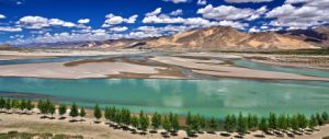
In fact, the Yarlung Zangbo is a major international river, shared by China, India and Bangladesh. It flows from its source on the slopes of holy Mount Kailas on China’s Tibetan plateau, before taking a sharp turn down into India (where it is known as the Brahmaputra) and on into the low lying mangroves of Bangladesh. Finally, it spills into the vast oceans of the Bay of Bengal. The river’s source area forms part of Himalayan watershed, known as the water tower of Asia, because it feeds the rivers that sustain some 1.3 billion people.
Until recently, the Yarlung Zangbo was one of the world’s last undammed rivers. But last year, China built its first large-scale hydro dam on the river’s middle reaches, and it has many more on the drawing board. India is pushing through its own plans.
Downstream, scientists and policymakers in Bangladesh are meanwhile trying to deal with the rising frequency of mega floods seen over the past decade and reduce damage from salt water intrusion as sea levels rise. Once in Bangladesh, the Yarlung Zangbo becomes a massive moving braided system, immensely destructive and hard to manage. Many fear that construction upstream will only make this situation worse.
Unfortunately, very little is known about the ways in which the river is changing, limiting the powers of water engineers and policymakers to make informed decisions. This is partly due to the remoteness of large stretches of the river, as well as the fact it passes through politically disputed areas, meaning data is not shared across borders. Basic information about hydrology and sediment load that planners in other countries take for granted is simply not available for the Yarlung Zangbo.
Inappropriate engineering could be catastrophic, particularly considering regional climate-change impacts: temperatures rising above the global average, melting glaciers, increasingly erratic rainfall. While individual dam projects have been assessed for their impacts on water flow, ecology and people (though experts question how thoroughly) the cumulative impact of river infrastructure within countries, let alone across borders, has been completely overlooked. Water engineers might as well be building in the dark.
Amid the lack of information and political suspicions, debate has been framed by emotion and rumour, driven by alarmist media reports. It was in an attempt to dispel some of these myths, that the third pole, a chinadialogue project organised a media workshop in October in Kathmandu – considered neutral ground. The event brought together scientists and journalists from China, India and Bangladesh to discuss the impacts of climate change and development projects on the Yarlung Zangbo River basin.
Chinese scientist Yang Yong, based at the Hengduan Mountain Research Institute in southwest China, sought to clarify some of the misunderstandings about Chinese water-control projects. He confirmed that, while the more controversial plans to divert the waters of the Yarlung Zangbo have been ruled out by China’s Water Ministry, a scheme to build the world’s largest hydropower at Motou on the “Great Bend” of the river (just before it enters India) are still firmly on the drawing board.
But Yang tried to reassure participants about the potential impact on India and Bangladesh, saying that this 48,000-megawatt dam (over twice the size of the Three Gorges dam) would not impact the flow of river water downstream. His field research has shown that the outflow of the river once it reaches India is more than two times greater than at the point of the proposed dam site. “Downstream countries’ concerns about the impact on river flow are not scientifically based,” he said.
And, amid the media hype about mega-projects, the real hazards have been overlooked, Yang warned. Climate change is already causing major environmental problems on the Tibetan Plateau and in the river basin: snow lines creeping higher, accelerating glacier melt (on average 200 metres to 500 metres over the past 20 years) and widespread desertification and degradation that has turned vast swaths of the river basin into sandy dunes. Mudslides caused by glacier avalanches are also on the rise.
The greatest risk of all, Yang continued, comes from seismic activity. The Himalayas and Tibetan plateau were formed by the collision of tectonic plates and earthquakes are common in Tibet. Metog county, where many Chinese dams are planned was struck by a massive quake in the 1950s, and according to scientists’ calculations, another big one is overdue. The site of the proposed Motuo hydropower site is particularly vulnerable, situated at the confluence of three big mountain ranges, within a gorge over 5,000-metres deep.
Indian scientist Partha J Das, from NGO Aaranyak, pointed out that these warnings are just as pertinent for Indian authorities, who have proposed 70 large hydro projects along the basins of mainstream and major tributaries of the Yarlung Zangbo on their side of the border.
These “common threats”, he said, provide an opportunity for collaboration between China and India, a potential vehicle for “water diplomacy”. For instance, in June 2000, a landslide blocked the Yigong Zangbo River (a tributary of the upper Zangbo). The landslide dam eventually burst, triggering a flash flood that damaged property and infrastructure in China and killed 30 people and displaced more than 50,000 in northeast India. Chinese scientists predicted the flash flood in April 2000, but Indian authorities ignored the warning. “Much of the disaster could have been averted if this was widely publicised by media in both countries,” Das said, calling for a bilateral treaty to exchange hydrological data and collaborate on flood forecasting and early-warning systems at both government and community levels.
Another workshop participant, World Bank economist Claudia Sadoff, tried to debunk other myths about big dams, arguing that they do not always mean trouble: “Upstream dams can control floods and have positive effects on salt water intrusion in Bangladesh,” she said. “It is not about whether or not there is a dam, but how it is designed and operated.” She called for the establishment of a Brahmaputra River Commission and information based treaties to capture “shared benefits” and “win-win solutions”.
Some were cynical about the possibility of such a harmonious approach. “How can we balance the objectives of three such different countries with such different needs?” asked one Bangladeshi reporter in despair. But the group of journalists welcomed the rare opportunity to hear voices from their neighbours, and were struck by common challenges the countries face, despite their differences. “This kind of exchange will help send the message back home on the impact of mismanaging information systems on other countries,” one Chinese journalist said.
“The media and NGOs need to show their governments that cooperation is in everyone’s best interests,” said Yang. And while Asia’s policymakers continue to behave like frogs down their own separate wells, refusing to look out at the sea, their voice is more vital than ever.
Beth Walker is a researcher at chinadialogue’s project the third pole.
Homepage image from xiaohaidacong