Professor Lonnie Thompson is one of the world’s leading paleoclimatologists and a pioneer of high altitude ice core drilling. When Thompson was a young postgraduate student, ice science was focused on the polar regions. He believed, against the prevailing scientific opinion, that ice from ice cores from glaciers in tropical mountain ranges would reveal more about the world’s climate history. He has since collected high altitude ice samples all over the world and was the first scientist to drill in the glaciers of the Himalayas. Here, he talks to chinadialogue’s editor Isabel Hilton about the risks and rewards of thinking differently, and his experiences in Tibet.
Lonnie Thompson: We were too far out in front in the beginning and there was a lot of opposition to these ideas, but that also makes it exciting. The history of science changes by paradigm shifts and the big breakthroughs come when someone sees the world in a different way. Look at Galileo: he calculated that the earth was round when people believed that it was flat, and he got tied up outside the churches in Europe. One of the oldest societies on earth is the Flat Earth Society, formed back in 1557 to prove that Galileo was wrong. It is still out there, even though we have orbited the earth. It wouldn’t matter to them what the evidence is.
Isabel Hilton: Are the established authorities a particular problem for new ideas in science?
LT: Yes, it is a big problem. If you are successful, people think your opinion has more weight than someone else’s, especially that of a young person. I started out in polar regions, but there was a whole world that nobody was looking at, while in the polar regions people were stumbling over each other. When I went to look at the tropics I was told it would wreck my career – and that took a long time to change. A colleague of mine says that science advances one funeral at a time, and there is a lot of truth in that. So I try very hard when young people come with an idea, even if I don’t think it’s a great idea. I am open to the fact that we don’t know everything and you never know where the next great idea will come from.
When we look at the Earth, 50% of the surface area is between 30 degrees north and 30 degrees south, and 70% of the population live in the tropics. If you want to change the climate of this planet, do something in the tropics. El Niño affects global climate because it affects both hemispheres.
You can have a huge volcanic eruption in Alaska and it will impact the Arctic, but it will not be global. Put it in Indonesia and you will have a global effect. So I think that the big drivers of climate on this planet have always come from the tropics. Science as we know it developed in Europe and on the east coast of the United States, so we have a lot of data from Greenland and the north Atlantic. The huge tropics are hard to get to, so we have very little data.
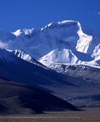
This is the case on the Tibetan plateau. We started working there in the mid-1980s, not knowing anything about that part of the world. We didn’t even know for sure that there were ice caps, because the place had been closed to foreigners. Before relations were normalised between the US and China, we couldn’t get in. But I had written to Si-Ya Feng, director of the National Institute of Glaciology, and in 1978 we met in Canberra and talked about the possibility of drilling an ice field.
IH: Did you have any idea in 1978 of how important this region was going to be for climate change?
LT: No. In the late 1970s, there were discussions about the next Ice Age. Our main purpose was to connect the histories of Antarctica and Greenland with the things in between – the tropics, Tibet – and put together a global picture. Those polar records had been sold as indicators of global climate for the world, but it doesn’t work that way. You don’t get monsoons or El Niño in the polar regions. So that was the initial motivation.
We started taking photographs and mapping every year or two. If you get a data point and start plotting these up, you see that these glaciers are not just retreating: their retreat is accelerating. Some of them are retreating 10 times faster than they were when I started. It is huge.
In Tibet the problem was mainly logistics: can it be done? How do you get an ice core out of Tibet and keep it frozen when you are using trucks designed before World War II, getting the right people, the right permits and all those things that go into making it successful. On my first trip to China, I spent three months alone, not speaking the language, with six weeks in the Tian Shan mountains in western China. I would take long walks with Yao Tandong, then a graduate student, talking about science and what the future might be. But neither of us could have conceived of how this would play out.
I remember going to dinner in Lanzhou with Yao and his wife and his daughter, to a little restaurant that had kerosene lanterns and no restrooms, to have some Lanzhou noodles. Now he is director of an institute that has just completed a campus in Lhasa, with a campus in Beijing and he’s in the National Academy in China. It all started with this very small idea in a remote part of western China. In the second six weeks I went to the Qilian Shan mountain range, where we found the Dundeice cap which became the site for our first drilling in that part of the world.
IH: What do we know about the state of Himalayan glaciers?
LT: We are just finishing the analysis of some cores we drilled in the southwestern Himalayas. It is at 6,000 metres, at the source of the Ganges, the Indus and the Brahmaputra rivers, and it has ice fields. In 2006, we drilled three cores to bed rock – the deepest is 158 metres. The first things we look for in these cores are records of all of the nuclear bomb tests that man has done in the atmosphere. These leave a radioactive layer around the earth, and you can find it in every glacier. All four earlier sites that we had drilled in Tibet had the Soviet test from 1962-63: it was the biggest atmospheric test ever conducted and it left a huge radioactive layer. But when we analysed these cores it wasn’t there.
We looked for an earlier series of tests that the US did in the South Pacific starting in 1951. They are unique because they were done at sea level and produced a radioactive chlorine — this was before we realised how dangerous these nuclear tests were. This Chlorine-36 went around the world and we found it in the ice fields of Kilimanjaro, in the Andes and in Tibet, but it was not present in this ice field. So it told us immediately that there has been no net accumulation there since at least 1950.
From other tests we know that the first layers there now were formed back in 1946-1947. In other words, these ice fields at 6,000 metres are losing mass from the surface down. A glacier needs an accumulation zone and an ablation zone, so these are being decapitated. In Kilimanjaro in Africa, we put stakes on ice fields in 2000 and we have measured that we have lost over 2.5 metres of solid ice from the surface from the highest place on that mountain. They are also being decapitated which means the rate at which these glaciers will disappear and water supplies will be impacted is much higher.
One of the things that really needs to be done in Tibet is to determine how widespread this phenomenon is. My guess is that the glacier we drilled in 1987 in the Dundeice field will be losing mass now from the surface down, since it is only 5,300 metres high. So determining the scale at which we are losing ice from the surface down and at what elevation are glaciers still accumulating is important.
IH: Are some glaciers still accumulating?
LT: I am sure they are. The highest place we have drilled in the Himalayas is 7,200 metres (23,500 feet), in 1997. The accumulation was about 1,200 millimetres of water a year since it is a very heavy monsoon climate. My guess is that at that elevation, where it is colder, glaciers are still accumulating. But as the earth warms, we expect this melting line to move higher and the bigger volumes of ice are at lower elevations where there are more mountains. Millions of people live downstream on these major rivers and would be impacted by the loss of these glaciers.
Our models talk about ice loss from the terminus and melting up from the lower elevation, but here we have these glaciers that are losing from the top down, so the change will come much faster. They are dying. The definition of a glacier is ice that is in motion. If there’s no accumulation, there’s no forcing for the motion, so they just sit there and die. We have to determine the scale of this and discover whether this has ever happened before.
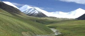
We have come a long way in Tibet, but there is so much more that needs to be done really to understand that system. The warming impacts the permafrost and there is a lot of concern about the grasslands. As the permafrost melts, the water that sits on top is going to disappear. What is that going to do to the grassland and the ability of people to feed themselves? You don’t see yaks in zoos because bacteria and viruses attack them at lower elevations. They have evolved to live at high elevation. How are they going to be impacted by these changes? I have to believe there are going to be some positive impacts – perhaps the ability to maybe graze higher pastures. With change there are always winners and losers, but the problem is that people have clustered in places that are good. If things change, they have to move.
And with development a lot of soot is being released into the atmosphere so there are radiation feedbacks. Does increasing soot change the albedo of the glaciers and cause them to melt faster? There are a lot of unknowns.
IH: Seen from space, this is a single region. On the ground there are international borders, with past conflicts and continuing tensions. How much scientific cooperation is there – and what are the obstacles?
LT: I often feel I am fortunate to be a scientist, because scientists realise that the processes that we are studying are not contained by borders. I think that our ability to get into China at a very early stage had to do with what we do for a living; we are not selling anything and we will never make a profit from what we do. We are interested in what the records show from the past and what they can tell us about the future, and to answer these questions you have to work across borders. Scientists realise that the glaciers don’t stop at the border. But it takes time for things to change. On my first trip to China to the Tian Shan mountain range, I was given a map with a line drawn where I could go. Even when the glacier went over the pass and down the other side, I couldn’t go.
IH: Because you were a foreigner?
LT: Yes – the first American scientist in this remote part of China
IH: To do this very dangerous science, you need a particular combination of mountaineering skills and science – and maybe to be a little bit crazy. In most of the countries where this phenomenon is occurring, that combination is hard to find. Is this changing now?
LT: I think it is a rare combination. We have lots of graduate students who want to join our programme because they want to climb mountains. I normally don’t take students who are just mountaineers. To me, the science always came first. I am not a person who would go out and climb a mountain at weekends, because they are dangerous and uncomfortable.
IH: Given how difficult it is to do and how many glaciers there are, are remote sensing and satellite data feasible as substitutes?
LT: They can help, but there will never be a substitute for data. Models are great for getting large-scale ideas for explaining a record where you have data. But ideas come from real data. Satellites collect data from algorithms but you have to interpret it with ground-based data. At Kilimanjaro, we drilled the ice core records and we made some projections on when these ice fields would disappear, based on how they had behaved over the last 100 years. The modellers published papers saying the glaciers are in near-equilibrium with today’s climate. But eight years after they took their photographs, those glaciers are almost gone. The models don’t tell you, it’s the data and the observations that really show you what is happening.
Tibet is a huge place, so you need very precise data from different parts of the plateau to interpret what you can see from the satellites. They work hand in hand. A model is not reality. Reality comes from measured data in the real world. This concerns me about science. We have so many people who spend their time in front of a computer screen, working on models or scanning something on a satellite image. We need those people, but they need to get out in the field. In my lab if you are working on measuring chemistry, or dust or isotopes, you have to go on at least one expedition, because you need to know something about this environment. You need to appreciate how hard it is to get these samples and how precious they are. The only way you fully realise that is by going out to experience it.
Isabel Hilton is editor of chinadialogue
Lonnie Thompson is a paleoclimatologist and distinguished university professor in the School of Earth Sciences at the Ohio State University.
Homepage image licensed to Lonnie Thompson